September 2018
Last of the Big Tuskers – Visual Effects
Animated by Dane Aleksander with Autodesk Maya, rendered with Mental Ray.
Continued from Part 1: Poster.
Simple graphics can be good. Simplistic can be clean. Realistic graphics have to be good to be cut with real footage. Then there is everything in-between. James shared an early edit of the film to review where the maps were requested. We considered what motion was required, which direction and why and so on.
The film called for five (or six) maps. The maps all had to be consistent and each of them had to fit into the flow of the film. One particular map had to represent movement from South Africa to China, Hong Kong and Vietnam. We wanted this motion to transport the audience. There are any number of ways to communicate this geographic representation. We considered just a few art directions: infographic, painterly graphic, photographic. We looked at respective relevant examples of these three different directions. However, any direction away from satellite-like photographic imagery had to have a ‘raison d'etre’ in the film. This film represented an adventure to-and-from key landmarks for elephant conservation in Africa and so, the imperative for the art direction was clarity.
We looked at an overlayed data visualization of Earth in a Netflix original documentary, The Ivory Game (2016). This graphical representation is animated less like a planetary model, and more like a desk globe or computer-generated model—more appropriate in the context of an undercover story that imparts a tasked course of action for its protagonist. Like a simplified, neutral white version of Tony Stark's JARVIS in Iron Man (film, 2008) and Iron Man 2 (film, 2010) and so on.

The Ivory Game (2016) © Terra Mater Factual Studios, Vulcan Productions [theivorygame.com]
We looked as well at a minimalist painterly representation of Earth in an animated short film directed by Kathryn Bigelow, Last Days. This animated short film traced an illegal ivory trade route from Asia back to Africa. The minimalist painterly example represents one of a range of abstract art directions, which presented another opportunity to extend the character of the cover art into the film.

Last Days (2015) © Annapurna Pictures [lastdaysofivory.com]
We looked at last at a satellite image (or satellite-like imagination) of Earth in most BBC Natural History Unit documentaries, in this case in the Nature's Great Events series, episode 3: “The Great Migration”. The images of Earth from space carry a certain significance—a reminder of where and who we are. This reminder is less pronounced when the representation is more abstract or more neutral. This particular episode of Nature's Great Events tracked the seasonal migration of wildebeest in Africa, in a round about route, which is represented with bright and semi-transparent yellow-gold paths on satellite-like motion graphics.
More about the documentary series:

Nature's Great Events e/3 “The Great Migration” (2011) © BBC [bbc.co.uk]
We realized no reason to pursue an art direction for the maps apart from realistic. The satellite view of Earth is a familiar image that carries contextual meaning and manages visual complexity without being a distraction from the message: the location, the path of adventure, the added layer of information.
We appropriated assets from personal and open-source projects to create a digital model of Earth. The visual effects were rendered based on high-resolution satellite image data from the NASA project: Blue Marble, in combination with a computer-generated model of geosynchronous Earth orbit (GEO) and low Earth orbit (LEO) satellite systems. We referenced existing satellite and camera technology to maintain the familiar perspective – from space – and not venture into the surreal. We wanted to keep it real.
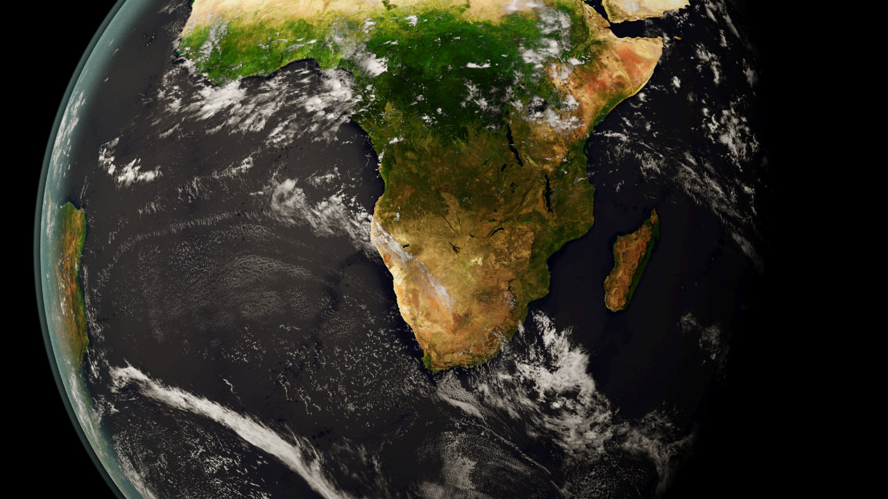
Last of the Big Tuskers “Blue Marble”
This image was rendered as a concept, with open-sourced satellite image data mapped to a computer-generated model of Earth, and with a view from a GEO satellite over southern Africa. We locked the art direction, simulated the trajectory of the satellite systems, and recorded a view for a window of time – over a given location – for each map sequence. Each map sequence indicated select international borders and national parks. Each frame was simulated then rendered in fifteen-to-thirty minutes with relation to the size of the indicated areas on screen. A few months of setup and review – plus three weeks, two days, twenty-one hours of render time – and we had our five or six maps. The renders were composited as layered uncompressed 32-bit color-depth image sequences, and encoded as Rec.709 DNxHR 4.4.4 compressed videos to integrate with the Avid editing system. The map graphics are pictured for a total of one minute and thirty-seven seconds. (2,425 frames at 25 frames per second.)
The first map sequence in the film is there to create a space for James to introduce the audience to Tembe Elephant Park, South Africa. The next map sequence is there to highlight Tembe Elephant Park in the context of Mozambique. Everything in the film is relative to Tembe. The last map in the film is there to place James on his adventure to Tsavo National Park, Chyulu Hills National Park and Amboseli National Park in Kenya, “far to the north of [Tembe Elephant Park].”
Last of the Big Tuskers “South Africa”
Last of the Big Tuskers “Mozambique”
Last of the Big Tuskers “Kenya”
This project page is concluded and is archived as a case study.
Client Team
James Currie, Ashley Smith.
Thanks to the team at NASA Visible Earth for additional graphic data, in particular The Blue Marble collection. Thanks to the ESRI Conservation Group for additional map data, in particular the Maputaland Center of Endemism, as well as OpenStreetMap and its contributors for additional map data of national parks. Thanks again to James Currie for the opportunity to contribute to his story.
Iconography
Satellite view of Africa: Amboseli National Park, Chyulu Hills National Park, Kruger National Park, Kenya, Maputaland, Mozambique, South Africa, Tembe Elephant Park, Tsavo National Park, and the ivory trade route(s) to China, Hong Kong and Vietnam.